
05
Service 05
Digital twins fuse IoT feeds, GIS, and 3D basemaps so cities and operators can monitor assets, simulate scenarios, and respond faster. We help structure geospatial foundations that scale from pilot districts to enterprise rollouts.
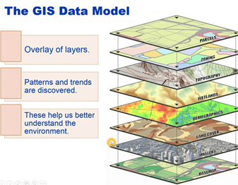
Web GIS and twin viewers bring utilities, mobility, and public works data into a common map experience — with role-based access and APIs for integration.
Aerial, MMS, and survey inputs refresh the twin's geometry so analytics and alerts are always tied to current conditions on the ground.